
|
|
|
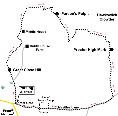
To view route as a dynamic Ordnance Survey map click here. Introduction: The majority of walks in the Malham area follow well used routes, arguably too well used, although it is such a striking area, this is hardly surprising. However, this walk is different as, in large part, it takes you “off piste”, to take advantage of designated open Access Land. This makes navigation a bit more challenging, although I will do my best to guide you. One advantage is that off the footpaths, you will probably not meet anyone; I didn’t and it was a glorious day. There are a couple of places where you need to get over a wall or gate but these are not difficult as long as you are reasonably agile. The ascents/descents are not particularly steep and you are rewarded with some absolutely fabulous views. The walk starts by climbing Great Close Hill (465m high), normally by-passed on paths either side but worth climbing for the great view over Malham Tarn. It is also topped by an ancient cairn, possibly Bronze Age. Most of this is under the turf but loose stones look to have been arranged into a crude shelter. There are views on a clear day to Sharphaw and Roughaw (just outside Skipton), Pendle Hill and Rylstone Edge. The next objective is Parsons Pulpit (538m high) the highest point between Malham and Littondale and providing a fabulous 360° view. Its summit is indicated by a square concrete platform on the ground where a trig. point once stood. Close by is an Ordnance Survey benchmark. The final summit is Proctor High Mark (520m) with some interesting cairns, including one giant cone shaped one, fine views and various mining remains – shallow pits in the ground. There are no facilities en route but some handy rocks for a picnic. After the walk, there is a choice of refreshment opportunities in Malham. The walk starts at Street Gate close to Malham Tarn. The easiest route to describe there is to turn north off the A65 just inside the eastern boundary of Gargrave and follow the signs for Malham. In the centre of Malham, turn right past the Listers Arms and after about three hundred yards, turn left for Malham Tarn. The road twists and turns a bit but after two miles, you reach open land. When the road turns sharp left, you have arrived at Street gate. Parking is on the grass at the roadside. Start: At the parking spot at Street Gate, with Malham Tarn ahead but left of you, walk ahead on the broad track to the left of the wall. Go through a farm gate (SD 905664) and immediately branch off left, heading for the far corner of a copse of trees. From there, leave the official footpath and make your way up the dome of Great Close Hill ahead. Depending on recent footfall, there may or may not be vaguely trodden turf and it is a case of making your way as best you can to the cairn at the top (SD 902668).
From the cairn, descend the other side of the hill in roughly the same direction in which you arrived. I headed just west of north for a couple of hundred yards (338° magnetic), then switched to NNE (026° magnetic), although the target is the path you should be able to see at the bottom of the hill and the precise direction is not critical. Turn right along this path, towards Middle House Farm. At the farm gate, branch off left, at about 45 °, along the obvious footpath heading gently up the hill. At the top of the hill, go through a gate and follow the obvious track, as it bends right at 90°. Arrive at a wall, then turn left to follow the stony track. You pass a fingerpost indicating “Arncliffe 2¾ miles” (continue in that direction) and shortly arrive at the atmospheric, semi-derelict, moss covered farm, Middle House (SD 907682). There are good views of the rocky outcrops on the side of Height – virtually part of Parson’s Pulpit.
After a further half a mile, cross a stone step stile and immediately leave the main footpath to head right at about 45° to the wall. There might (or might not!) be a faint path. Keep climbing gradually and look out for an area of limestone pavement on the left. Just before this, curve right around a rocky outcrop.
As you approach the junction of two walls, turn right to climb a small hill. At the top of this, the somewhat dilapidated state of the wall enables a relatively easy crossing. Once over the wall, turn left to walk parallel with it. Head for the little col (SD 916690) between the two small hills, from where there is a fine view, towards Great Whernside.
From the col, turn right to climb Parson’s Pulpit (SD 918688). At the highest point, you will find the old trig. point base and the OS benchmark. Enjoy the view before continuing roughly in the direction as if treating the benchmark as an arrow (143° magnetic). Drop down to walk between an “avenue” of rocky outcrops where there are sheltered spots which provide potential picnic seats.
Beyond the “avenue”, follow the wall on the left to a sheep pen area and make your way through the gates, exiting after the pen through a gate on the right. Keep straight ahead with the gate behind you until you reach a broad track where you turn left, at an acute angle, resuming an official footpath (SD 923678). You can cut the corner but if you carry on to the junction proper, there is a fingerpost. To the right is “Street Gate 2 Miles” but you go left following “Arncliffe Cote 2½ miles”. At SD 926682 you get to a gate. Do not go through it but leave the official footpath once more turning right to follow the wall, now on your left.
Follow the wall along until you reach a farm gate on your left (SD 929682). Turn sharp right along a shallow valley. After a hundred yards or so, the path veers right, down a much steeper valley but you carry straight ahead to climb the hill immediately ahead. On this hill you pass what I call Rabbit Rock for obvious reasons – see photo.
From Rabbit Rock, drop down to a ‘T’ junction of two walls (SD 933680). The “leg” of the T points way from you. You need to scale this wall and keep to the right of the wall opposite. If you look closely and over the wall, there are some “through” stones which provided the equivalent of a stile. Follow the wall along, passing a small rocky outcrop/scar. Just before the second outcrop/scar turn right. There was a visible grassy track on the ground when I did the walk. After about two hundred yards, bear left at SD 936678 to climb Proctor High Mark. After about a hundred yards further, bear right to a large cairn (or possibly spoil heap) at SD 937677, which you should be able to see. From here, head to a smaller cairn which actually marks the summit at SD 937676. From here are more fine views.
Next, head for the large prominent neat cone shaped cairn to the SE (SD 938675). Evidently this is built over a mine shaft, according to a bit of Googling. As you approach, on the horizon, is Rylstone Ridge.
From the cone cairn, drop down slightly heading right, relative to your line of approach. You will meet a broad grassy track. Turn left. Meet a second broad track and turn left (SD 937671) When the track splits, keep right. Go through a gateway and follow a wall down for about seventy-five yards then turn right on another broad grassy track. The track leads down to a five bar gate. This was padlocked on my journey so had to be climbed. Always climb, one at a time, at the hinge side to minimise leverage strain on the hinges. Once over the gate, turn right along Mastiles Lane, leaving the open Access Land.
Arrive at a three way fingerpost at a gate. Go through the gate and turn right, following “Public Bridleway Street Gate 2 miles”. You will pass an information board on the right about a Roman camp but there is nothing to see on the ground.
Stay on Mastiles Lane, crossing the ford of Gordale Beck via an old clapper bridge, until you reach where you parked. If you need to buy any hiking equipment/clothing before your trip see the Hiking Store All information on this site is given in good faith and no liability is accepted in respect of any damage, loss or injury which might result from acting on it.
| | |||||||||||||||||

.jpg)
.jpg)
.jpg)
%20Malham%20Tarn%20from%20Great%20Close%20Hill.jpg)
%20Cairn%20on%20Great%20Close%20Hill.jpg)
%20View%20over%20Middle%20House%20Farm.jpg)
%20Middle%20House.jpg)
%20Rocky%20scars%20of%20Height.jpg)
%20Limestone%20pavement.jpg)
%20View%20from%20col%20to%20Great%20Whernside.jpg)
%20View%20from%20Parsons%20Pulpit%20towards%20Great%20Whernside.jpg)
%20Site%20of%20old%20trig%20point%20on%20Parsons%20Pulpit.jpg)
%20OS%20benchmark%20on%20Parsons%20Pulpit.jpg)
%20Turning%20off%20path%20to%20Open%20Access%20Land.jpg)
%20Rabbit%20Rock.jpg)
%20Summit%20cairn%20Proctor%20High%20Mark.jpg)
%20Cone%20Cairn%20and%20Rylstone%20Ridge.jpg)
%20Mastiles%20Lane.jpg)
%20Great%20Close%20Hill.jpg)