
|
|
|
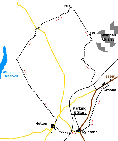
To view route as a dynamic Ordnance Survey map click here. Introduction: For a cold winter’s day, I was looking for a relatively short walk with an opportunity for a pub lunch and this circular walk from Rylstone to Boss Moor via Hetton fitted the bill, the target pub being the Devonshire Arms at Cracoe. The usual objective for anyone starting from Rylstone is the ridge which overlooks the village, bearing the Rylstone Cross and Cracoe War Memorial but I have done this several times and I though it would be interesting to heads in the opposite direction. There is a slight overlap with my Hetton to Winterburn Reservoir walk. Rylstone’s main claim to fame is that it is home of the real Calendar Girls and it featured in a poem by William Wordsworth, The White Doe of Rylstone (or, The Fate of The Nortons). This is too complex a tale to explain here! It has a pleasant village pond, which possibly replaced the village green, to provide a reservoir of water in the event of fire in the village and/or it may have provided water for a local mill. Rylstone has a nice church, St. Peter’s which is set back from the main road and which you will pass on the return to the start. Hetton is a quiet, attractive village with houses built of local stone. Its main claim to fame is as home to The Angel, a ‘gastro’ pub, famous for the quality of its food. Cracoe like Rylstone is on the busy B6265. Close to Cracoe are the Cracoe Reef Knolls, a collection of low lying limestone hills which contain the remnants of a pre-historic ocean. One of my walks (Linton to Elbolton) visits one of these hills. Cracoe also featured in the Calendar Girls. The Devonshire Arms at Cracoe had excellent food and beer and is recommended. Cracoe War Memorial, to the locals who perished in the two World Wars, sits at the northern end of the ridge overlooking the village and is in the form of a massive obelisk. The ground was pretty much frozen when I did the walk but after wet weather, you will appreciate gaiters! It is an easy walk in the main on clear tracks/lanes. The walk starts from a lay-by yards north of the village pond at Rylstone, on the B6265 between Skipton and Grassington. Start: From the lay-by (SD 969587), turn right along the road to the village pond and then turn right along its right hand side, following a public bridleway fingerpost. Follow the path through to a tarmac lane and turn right along it. You soon pass under the railway bridge and immediately after this, turn left following a public bridleway fingerpost for “Hetton ½ mile”. This is a really pleasant walled track then footpath emerging in Hetton’s main street. Ignore any other turn offs along the way.
Turn right along Hetton’s main street and after about two hundred and fifty yards, look out for a broad track on the left, opposite a barn conversion. Turn left following the fingerpost for “Weets Top 4 Miles” (SD 963590).
At SD 956599, ignore a broad track off to the left (shown as Cross Lane on the OS map) and continue straight ahead.
Continue along the track until you meet a gate (SD 951608). Go through it and turn right following the fingerpost for “Boss Moor”. It is this next section in particular where gaiters could be valuable!
Follow the obvious track across Boss Moor. After going through a gate it becomes a walled track. Follow it until you reach a road. You have a couple of choices here. a) Turn right and just after the cattle grid, turn left over a stile following a fingerpost for “Threshfield 2¼ Miles”. You need to bear off left at about 45° to the wall for a quarter of a mile to meet a broad track where you turn right. b) The path mentioned above can be difficult to spot and for more certainty, you could turn left at the road for a hundred yards or so to a rough parking area (SD 956619). Turn right here to join the same broad track. Very quickly you reach a fork, keep right. Follow the broad track and after going through a gate, fork left on another broad track (SD964621). After a short distance, join another broad track and turn right through a gate. You will reach a shallow ford (Hammerton Hills Syke) which can be circumvented by hopping over a small stream. Just beyond that, turn right following a public bridleway fingerpost.
Continue on the path until it divides and take the slightly smaller path to the right, by a small copse of trees.(SD972616). This leads down to Eller Beck which you cross via large stepping stone boulders.
Up the other side, turn right through a gate and follow the obvious path, arriving at a stone barn. The official footpath route is to the right of it but most obviously keep to the left (as I did). Ahead of you across the field are two somewhat redundant stone gateposts. Go through these and continue in the same direction to a gate. Through this, join a walled track.
Go through another gate with a two way fingerpost and turn right following the public bridleway sign. Pass under the railway bridge and turn left at the main road into Cracoe. For the return to Rylstone, turn right up a narrow lane identifiable by its “Unsuitable for Wide Vehicles” sign. Follow this through to a ‘T’ junction and turn right along Back Lane, until it reached the main road. This was my route after visiting the pub but if you wanted, you could turn right before this at Back Lane, directly off the main road. Either way, at that point, you follow a fingerpost for “Rylstone 1 mile”. After passing Rylstone Church, the track emerges at the village pond and it is but a few yards to the lay-by.
If you need to buy any hiking equipment/clothing before your trip see the Hiking Store All information on this site is given in good faith and no liability is accepted in respect of any damage, loss or injury which might result from acting on it.
| | |||||||||||||||||

.jpg)
.jpg)
.jpg)
%20Frosty%20Morning%20just%20outside%20Rylstone.jpg)
%20Walled%20path%20on%20the%20way%20to%20Hetton.jpg)
%20Footbridge%20over%20Skirse%20Gill%20Beck.jpg)
%20View%20to%20Rough%20Haw%20and%20Sharp%20Haw.jpg)
%20View%20NE%20from%20the%20Moor%20Lane%20track.jpg)
%20View%20to%20Cracoe%20and%20Rylstone%20Fells.jpg)
%20Looking%20along%20Moor%20Lane%20track.jpg)
%20View%20North%20from%20Moor%20Lane%20track.jpg)
%20View%20over%20Winterburn%20Reservoir%20to%20Pendle%20Hill.jpg)
%20North%20end%20of%20Burnsall%20and%20Thorpe%20Fell.jpg)
%20Ford%20ay%20Hemmerton%20Hills%20Syke.jpg)
%20Swinden%20Quarry.jpg)
%20Barn.jpg)
%20St%20Peter's%20Church,%20Rylstone.jpg)