
|
|
|
To view route as a dynamic Ordnance Survey map click here. Introduction: This
circuit was inspired by my noticing Ghaistrill’s Strid near Threshfield
when ‘reading’ my OL2 Yorkshire Dales - Southern & Western - map and seeking a
route to include it. Realising that I had never ‘bagged’ the trig. point
at New Pasture Edge, a modest circuit almost created itself. Most
Dales hiker are familiar with the Strid at Bolton Abbey and indeed it is
covered by my Bolton
Bridge to Barden Bridge and The Strid walk but this one at Threshfield
is perhaps less well known and certainly I had never visited it. In fact, I
now think in many ways, it is a more attractive spot being more open and
certainly less crowded. The
word strid is believed to come from the Old English for ‘stryde’ or
'stride', where a river may be crossable with a stride – though I would
not try it. A large volume of water is squeezed between precipitous rock
cliffs, often very deep and it is virtually certain that if you fell in you
would be terminated! Now
for Ghaistrill. Gastill is a known local name and could easily have been
corrupted into Ghaistrill over the centuries, though whether anyone of that
name had a connection to this place is not known. Another possibility is
that it comes from Old English ‘gāst ' meaning ghost and ‘thiril’
meaning hole. So why ‘ghosthole’. It transpires that in 1768 a Tom Lee
was put on trial and hanged for the murder of Richard Petty, the local
doctor. His body hung in gibbet irons from a tree near the murder site in
Grass Wood and after a lengthy period of decomposition, his bones and irons
were thrown into the river at this point – or so the legend goes – hence
the alleged haunting and the name. Maybe just do not go there after dark
(just in case!). The
walk also visits Conistone, an
attractive village, the lordship of which was bought by villagers in 1583.
This would have given them control of local farming and mining as opposed to
being beholden to a lord of the manor. As
you enter the village, you pass Conistone Keld, ‘Keld’ coming from an
Old Norse word ‘Kelda,’ meaning spring. At one time, this was probably
the main source of water for the village. There are three troughs to collect
the water and a cobbled area in front. The Keld was restored in 2018. The
centre of Conistone has a triangular walled ‘island’ where there is some
seating; handy for a picnic. One
disappointing aspect of this walk on the day I did it was the poor
visibility, which also hampered photographs. I have done many walks in this
area over the years and ordinarily there are great views. There
is some road walking but on quiet lanes. The
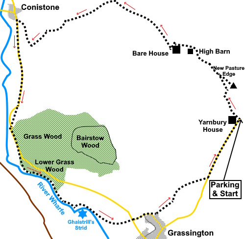
walk starts from a rough parking area opposite Yarnbury House on Moor Lane
above Grassington, which was built in 1826 by the Duke of Devonshire, the
landowner in this area, for the Duke’s Mineral Agent, in connection with
the extensive mining in the area (see Grassington
Lead Mines and Mosdale Scar and Hebden
to Grassington via the Mines) To
get to Yarnbury House, from the main crossroads in the centre of Grassington,
follow Main Street to the top, then continue straight ahead along the no
through road, which is Moor Lane. Parking is on the right after 1.3 miles,
opposite the house. This
being a circular walk, you could also start at Conistone where there is a
car park or indeed from Grassington, which is skirted on the return leg of
the walk. Start: From the parking area (SE015659), cross the road and take the track to the right of Yarnbury House. You soon get to some gates where you bear off to the right following a yellow footpath arrow. The route of the path is clear on the ground and well marked between old mine heaps.
Join a broad walled track and turn left (SE 014663).
Should you wish to ‘bag’ the trig point on New Pasture Edge (SE 014664), turn right through a gate after about three hundred yards and bear right across the moor. It is only about three hundred yards to it. Return to the walled track and turn right.
Discounting the diversion to the trig. point, you follow the walled track for half a mile, ignoring a stone stile on the left just after a gateway. You should now be in sight of two buildings ahead. Fork left of the main track (SE 008669) and head for the nearest, right hand building (High Barn).
Pass the barn through the gate to its right and follow the wall on the left round to Bare House. Have a look round this forlorn building if you wish then return through the gate at its side.
With your back to the gate, follow the path ahead (roughly north-north-west 325°). At this stage, you are heading towards the radio mast on Wassa Hill.
Pass above a small copse of trees and a rectangular spring fed pool, then, after passing through the third gateway, there is immediately a clear fork in the path (SD 997676). Take the left fork. You are no longer heading towards the mast but downhill towards the Wharfe valley. This section is not a Right of Way as such but the path is clear on the ground and this is Access Land which gives you the freedom to use it.
Soon
cross over another clear path (SD 994676), keeping straight ahead. The path drops down a shallow gorge with limestone outcrops to reach a broad track running by a wall. Turn right and follow the track to Conistone village. If you want to visit the village, turn right, otherwise, turn left along the road.
Follow the road for three quarters of a mile. As it bends right, fork off left following a public footpath fingerpost for “Grass Wood Lane 360 yards”. This cuts off a corner of the road.
Rejoin the road and turn left for about a third of a mile. Look out for a path on the right indicated by a sign “Welcome, Woodland Trust, Lower Grass Wood”. Follow the obvious path, turning right at a junction of path (SD 986650) to the river. Turn left to follow it.
After about half a mile you will reach Ghaistrills Strid (SD 991645). It is pretty unmistakable with the water rushing through a narrow channel.
Continue
to follow the path and look out for a walkers’ gate and three way
fingerpost on the left (SD 994645). Through the gate, follow the path as it
curves left to e farm, then keep ahead on its drive. At
the road turn right for a few yards then left. You will arrive at an island
with a bench under a tree. Keep straight ahead. Follow
the road as it bends right by a farm and just after passing the 20mph sign,
turn left up a broad track signposted for (amongst others) “Dalesway
Footpath to Kettlewell”. At the top of the short slope, turn right up a
narrow path marked by a public footpath fingerpost to “Moor Lane” At
the top of some rough steps, cross a stone stile and cross on to a broad
track. Keep straight ahead, again following a fingerpost for “Moor
Lane”. When
the track opens into a field, bear right to follow the right hand wall
passing a barn. Cross a stile at the end of the field and follow the wall up
the hill and through the belt of trees ahead, crossing a ladder stile. After
the trees pass a bench (which you may be grateful for!) and keep ahead Moor
Lane where you turn left to follow it back to the parking area (just over
half a mile). If you need to buy any hiking equipment/clothing before your trip see the Hiking Store All information on this site is given in good faith and no liability is accepted in respect of any damage, loss or injury which might result from acting on it.
| | |||||||||||||||||

.jpg)
.jpg)
.jpg)
%20Looking%20back%20to%20Yarnbury.jpg)
%20Path%20to%20New%20Pasture%20Edge.jpg)
%20View%20towards%20Wharfedale.jpg)
%20Trig%20point%20at%20New%20Pasture%20Edge.jpg)
%20Heading%20towards%20Bare%20House%20and%20High%20Barn.jpg)
%20High%20Barn.jpg)
%20Bare%20House.jpg)
%20Bath%20at%20Bare%20House.jpg)
%20Looking%20down%20Wharfedale.jpg)
%20Spring%20below%20Bare%20House.jpg)
%20Waiting%20for%20traffic.jpg)
%20Heading%20towards%20radio%20mast%20at%20Wassa%20Hill.jpg)
%20Descending%20to%20Wharfedale.jpg)
%20Approaching%20Conistone.jpg)
%20First%20Sight%20of%20the%20River%20Wharfe.jpg)
%20Looking%20North%20along%20the%20River%20Wharfe.jpg)
%20Ghaistrills%20Strid.jpg)
%20View%20SE%20along%20the%20Wharfe%20near%20Ghaistrills%20Strid.jpg)