|
High
Force
|
Starting
point and OS Grid reference:

Car
park at Bowlees – voluntary contribution (NY 908283)
|
Ordnance
Survey Map
OL
31 North Pennines - Teesdale and Weardale.
Buy this map from
List
of OS Maps
Commission from map sales is
used to fund the website, so keeping it free to use.
| |
Distance: 6.5 miles
|
Date of Walk 3
October 2014
| |
Traffic light rating:


(For explanation see My
Walks page)
| |


For advice on .gpx files see
My
Walks page
|

Click
the PDF logo above to give a printable version of this walk without the
photos.
|
To
view route as a dynamic Ordnance Survey map click here.
Introduction:
Although I
call this the High Force walk, it also includes Low Force waterfall and
even if neither waterfall existed, the rest of the walk is worth doing for
the views of Teesdale. This really is a beautiful valley, within the North
Pennines AONB.
In the north of England, mention of the
“Whin Sill” crops up all over the place. It is a layer of a hard, dark
rock called dolerite, also known as ‘whinstone’, formed from molten rock
some 295 million years ago. It provides the edge over which the High Force
waterfall falls. It has dubious claims to be the highest waterfall in
England (which it is not) but its might is impressive enough nevertheless.
Low Force is more a series of cascades than a
sheer drop but still a respectable display.
The walk starts from the Bowlees Visitors
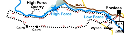
Centre car park with an unusual voluntary “Donate and Display”
arrangement (NY 908283). The car park is on the north side of the B6277,
about 3½ miles north west of Middleton-in-Teesdale.
There are no refreshment/toilet facilities on
this walk.
Start:
From the car park (NY 908283), follow the sign from its rear for the
Visitors Centre itself and High Force. Pass the Centre and on reaching the
road by a row of white painted cottages, turn right.
Follow the road to the ‘T’ junction with
the B6277. Turn right for only a few yards then turn off left to follow the
fingerpost for “Low Force and Pennine Way 300 yards” and “High Force 1¾
miles”. Shortly, go through a slit stile into the woods and follow the
path to Wynch Bridge over the River Tees. This current bridge was built in
1831. Cross this suspension
bridge. Note the sign - only one person should cross at once.
%20Wynch%20Bridge.jpg)
%20Low%20Force.jpg)
As you cross, there is a good view of Low
Force to the right.
Once over Wynch Bridge, there is an
information board about the falls. Turn right here to follow the fingerpost
for “Pennine Way, Bridge 1 mile and High Force 1½ miles”.
Follow the path along the river, passing a
sheep sculpture with the inscription “A Wonderful Place to be a Walker”.
How true!
%20Sheep%20sculpture.jpg)
You also pass a sign which tells you are
entering Moor House Upper Teesdale Nature Reserve.
At NY 889283, you pass Holwick Head
footbridge, leading from a large car park and the main access route for
tourists wanting to see High Force.
%20Holwick%20Head%20footbridge.jpg)
%20View%20before%20High%20Force.jpg)
You will hear High Force long before you see
it. Look out for a fork in the path with some black painted railings visible
and turn right. This is the best viewing point for High Force.
%20High%20Force.jpg)
Return to the main path and continue
following the river.
%20View%20above%20High%20Force.jpg)
%20Footbridge%20beyond%20High%20Force.jpg)
At NY 873280, you pass High Force Quarry,
across the river. The true scale of this becomes evident from high ground
later. Not far past the quarry, the path starts to climb and turns away from
the river. This is a beautiful stretch of the valley. There are a few rocks
here which make a good picnic stop with a good view. Across the river is
Dine Holm Scar, attractive despite the quarry next to it.
%20Dine%20Holm%20Scar.jpg)
%20River%20turns%20north.jpg)
As the ground levels out, you can see the end
of Cronkley/Green Hill scars. At NY 862283, you pass two Pennine Way marker
stones. Leave the Pennine Way here and take the left hand path to the fence
and turn left to follow it. Do not go through the gate.
%20One%20of%20the%20Pennine%20way%20markers.jpg)
%20Cronkley%20Scar.jpg)
At the bottom of the field, go through the
kissing gate and then straight ahead for about 300 yards, to join another
path at a ‘T’ junction, where there is a small cairn (NY 860280). Turn
left here.
The path closes on a wall, virtually meeting
at a stream. Cross the stream, then follow the right hand side of the wall
up the hill. When the wall turns 90° left, keep straight on up the hill,
away from the wall, to the top, passing a cairn. A few yards past the cairn,
follow the path as it curves left (NY 869276).
As you walk along the ridge, you can
appreciate the scale of the quarry.
%20High%20Force%20Quarry.jpg)
The path passes through a line of grouse
butts (NY 870276).
Continue along the path, passing another
cairn (NY 873276). After crossing a stile, there is another stream to
negotiate. There are rocks across which you can step.
%20Cairn.jpg)
On reaching a broad stony track, turn left,
following a public bridleway fingerpost.
On the left, there is a fence line and you
will eventually see where it turns left at 90°. A couple of hundred yards
before this, there is a stile on the left which marks the Right of Way (NY
890275). Cross the stile and head downhill. Although clear at first, the
route is not easy to follow as it weaves between the juniper bushes and some
bushes are fenced off (see footnote).
The best advice is to follow faint tracks towards the small boarded up stone
cottage below as the route goes clockwise round this. You emerge via a
walkers’ gate. Follow the track, crossing a couple of “planked”
sections, to the old cottage.
Go through the gate by the cottage and
clockwise round it.
Follow the track round the field, coming to a
stony track leading to Hield House (NY 895279). Turn right.
Keep on the track until, just as it starts to
climb towards a copse of trees, there is another track off to the left
between two large boulders. Turn left here.
Follow the track through a gate then head
downhill towards the opposite corner of the field. From the corner, cross a
short boardwalk, following the direction arrows, then drop down a little
bank to another path and turn left.
You will soon find yourself back at Wynch
Bridge. Retrace your steps to the car at Bowlees.
%20Approaching%20Bowlees.jpg)
Footnote
When
I crossed the stile at the fence, there was an empty notice board. When I
got to the walkers’ gate before the cottage there was a notice. Evidently
the juniper bushes are suffering some dread disease and certainly some were
clearly dead/dieing. The notice asked that walkers help protect the bushes
by walking around the entire fenced section, which would have meant not
crossing the stile but walking along the fence and following it as it turned
through 90°. Going through a gate would take you to the part of the track I
describe as “planked”. There is no suggestion that you cannot follow the
ROW if you insist, merely a request that you help. I was unaware until it
was too late and I describe the route actually followed.
If you need to buy any
hiking equipment/clothing before your trip see the Hiking
Store
All information on this
site is given in good faith and no liability is accepted in respect of any
damage, loss or injury which might result from acting on it.
|


.jpg)
.jpg)
.jpg)