|
Simonside
Hills Walk
|
Starting
point and OS Grid reference:

Simonside
car park (NZ 053988)
|
Ordnance
Survey Map
OL
42 Kielder Water and Forest.
Buy this map from
List
of OS Maps
Commission from map sales is
used to fund the website, so keeping it free to use.
| |
Distance: 6.6
miles
| |
Traffic light rating:


(For explanation see My
Walks page)
| |


For advice on .gpx files see
My
Walks page
|

Click
the PDF logo above to give a printable version of this walk without the
photos.
|
To
view route as a dynamic Ordnance Survey map click here.
If you need to buy any
hiking equipment/clothing before your trip see the Hiking
Store
Introduction:
The Simonside Hills is a sandstone ridge to the south of Rothbury culminating in
Simonside itself. It provides a fairly easy walk with good views across to
the Cheviot and over Rothbury and the River Coquet. Ancient cairns mark the
summit of the ridge. At Old Stell Crag in 1549, men of the valley kept
lookout for Scottish invaders.
The route crosses Cauldhole Moss, once said
to be the home of Will O’ The Wisp who lured unwary travellers. Also, the
Dueugar, a race of forbidding dwarves who did the same, were said to inhabit
the hills. I breathed a sigh of relief when I escaped unmolested!
The only tricky part of the walk is the steep
descent from Simonside but it should not present too much of a problem.
After this descent, there is something of a navigational challenge to
negotiate a felled plantation and moorland where the path is not clear. It
may be possible to turn right here and have an easy walk back to the car
park but I have not tried this – and where’s the fun in that!
The walk starts from the free Simonside car
park. To get there, turn north west off the B6342, at a sharp bend, about 3
miles south of Rothbury. The turn is marked by a brown tourist sign
“Simonside 2 miles”.
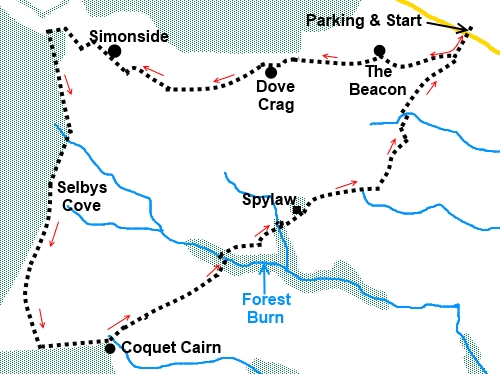
Start:
Leave the car park and walk
up the footpath across the road, passing the information board. A fingerpost
at the car park pointing in your direction of travel indicates “Spylaw 1¼
miles” and “Cocquet Cairn 2¼miles”.
%20Start%20of%20the%20walk.JPG)
After about 200 yards, the path splits at a
footpath marker post with yellow arrows (NZ 051986) Turn right. It is now a
simple case of following the ridge up and along.
You go through a walkers' gate and about 200
yards later, the path becomes “manicured” with stone laid to prevent
erosion. The path splits, the right hand path being marked with a white
arrow on a red background, Keep to the left path.
The first peak is Beacon Cairn (NZ 038985).
%20View%20along%20the%20ridge%20from%20The%20Beacon%20Cairn.jpg)
Next is Dove Crag cairn (NZ 038985) and the
path beyond here is laid with large stone slabs.
%20Dove%20Crag%20cairn.jpg)
You come to Old Stell Crag with its cairn (NZ
027985) and from here, the path arcs clockwise round to the left.
It is obvious when you reach Simonside (NZ
025985) itself because it drops away steeply to the west. Continue the walk
from Simonside top by walking left a short distance along the ridge on the
obvious path. It then starts to descend the steepest part of the walk and it
can be slippery with mud in/after wet weather. Some stone steps have been
laid lower down but did not cover the entire descent at the time of my
visit. Looking back at Simonside, the weather-worn bluff is an impressive
sight.
%20View%20back%20along%20the%20ridge%20from%20Simonside.jpg)
%20View%20towards%20Rothbury%20from%20Simonside.jpg)
%20Western%20face%20of%20Simonside.jpg)
Descend to a broad track and turn left,
ignoring the faint track to the left immediately at the bottom of the
descent by the information board.
The navigation now got tricky because an
extensive area of plantation had been felled and the tangle of discarded
branches etc disguised the path. If you have downloaded my GPS route, I
recommend using it from here as, more by good luck than judgement, I did hit
the succession of marker posts and the route is taken from the track
recorded as I walked rather then the OS maps.
About 100 yards from the information board,
look out for the path through the remnants of the plantation on the left (NZ
021988). It looks almost like a ditch but not far along it, you come to a
footpath marker post which confirms you are on the right route and that you
go left. The tangle of branches etc makes this bit hard to follow and the
best advice is to head just to the left of the few remaining trees standing.
You should come across marker posts. Obviously this could change if trees
are replanted – I did the walk in 2013.
Once you clear the corner of these few trees,
the path does become a little clearer.
The path across the heather is marked with
posts but unfortunately, you cannot always see the next in the series from
the previous one. If in doubt, head for the left hand corner of the
plantation ahead. If you are on target, you will cross a couple of plank
footbridges, coming out almost at the corner of the plantation.
The path is supposed to go through the
plantation briefly here but in practice, it is impassable due to fallen
trees. Ignore the path into the trees and make your way round the left hand
edge of the plantation across the moorland.
The path starts to bear slightly left away
from the trees heading towards a patch of slightly higher ground. There is a
fence across this higher ground and the path takes you to a stile at the
fence corner. Cross this and follow the path along the right hand edge of
the small but dramatic valley – Selby’s Cove (NZ 021977).
%20Selbys%20Cove.jpg)
As you get to the end of the valley, the path
starts to veer off right. As you descended, you should be able to see some
boarding across boggy sections of the moor in the near distance. Head for
this.
%20Looking%20back%20at%20the%20Simonside%20ridge.jpg)
The route is now clear across to another
plantation. You arrive at a stile (NZ 020964) but do not cross it. Instead,
turn left and walk along the edge of the plantation staying on the moor.
There is a well walked path.
You can see Coquet Cairn in the distance at
the corner of the trees though it is something of an anticlimax when you get
there!
%20Coquet%20Cairn.jpg)
From the cairn (NZ 025965), turn left to
follow the obvious path. When it appears to split, just after a marker post,
the left hand leg heading towards a gate, keep right.
Cross over a broad track.
The path becomes a broad track and descends
to a small wooded valley, through which flows Forest Burn. Follow it down to
the left and cross the footbridge (NZ
034970). Turn left after the bridge and look out for a footpath marker post
with the arrow pointing right, a few yards further on. You should see the
next post in the series on the skyline marking your route.
The path crosses a second wooded valley (NZ
038974) where the stream has been culverted. After crossing the stream, go
slightly right to a ladder stile.
You head to a copse of trees where the path
circles round to the right. In the trees is Spylaw Cottage belonging to
Blyth Valley Scouts (NZ 040975). You cannot see this until you are next to
it.
Cross the ladder stile and take the right
fork.
After going through a metal gate, come to two
ladder stiles and cross the left hand one. According to the map, the public
footpath now branches left across the moors but it is easier to follow the
broad track which is the waymarked route. Turn left at the next marker post.
After
crossing a wide wooden bridge, keep straight ahead and follow this path back
to the car park, passing the point where you began your climb of the
Simonside Hills.
All information on this
site is given in good faith and no liability is accepted in respect of any
damage, loss or injury which might result from acting on it.
|


.jpg)
.jpg)
.jpg)