|
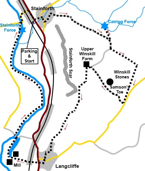
Stainforth to Lancliffe via Carrtig Force and Stainforth Force
Starting point and OS Grid reference:

Pay
and display car park at Stainforth (SD 820673)
|
Ordnance Survey Map
OL2
– Yorkshire Dales – Southern and Western.
Buy
this map from
List
of OS Maps
Note: If you use OS Maps on-line, you can download this route via this
link.
| |
Distance:
5.9 miles
|
Date of Walk:
11 January 2019
| |
Ascent:
Descent:
See Walking Time Calculator
|
647ft (289m)
646ft (288m)
| |
Traffic
light rating:  
(For explanation see My
Walks page)
| |


For advice on .gpx files see
My Walks page
|

Click
the PDF logo above to give a printable version of this walk without the
photos.
|
To
view route as a dynamic Ordnance Survey map click here.
Introduction: This
short walk from Stainforth takes you in a circular route through the village
to Catrigg Force and provides a shorter option to visit this, than my Settle
to Catrigg Force walk. You also get Stainforth Force thrown in for good
measure.
Catrigg
Force was a favourite of composer Sir Edward Elgar, where the waters of
Stainforth Beck fall dramatically for about forty feet over the North Craven
Fault, en route to feed into the River Ribble. The Force is situated at the
end of a secluded gorge, in a very atmospheric setting.
Our
route then continues via some limestone pavement at Winskill Stones. These
were badly devastated by extraction to provide rockery stone for gardens but
eventually the wildlife conservation charity Plantlife stepped in to save
what was left and this is now a nature reserve.
On
then to the village of Lancliffe. If you have only ever driven past it on
the main road, you could be forgiven for thinking there is little to it but
in fact it is much larger than it appears and is extremely picturesque with
a large village green where there are some benches should you want a lunch
stop
From
there, the walk returns to Stainforth via the banks of the River Ribble,
passing Stainforth Force, a dramatic cascade.
During
the walk, you get good views of the Yorkshire Three Peaks Ingleborough,
Pen
y ghent and Whernside.
The
walk starts from the pay and display car park at Stainforth where there are
public toilets. To get there, take the B6479 north from Settle. The car park
is unmistakable next to the road after a fraction over two miles.
Start: Exit
the car park and turn right. Follow the road as it bends right through the
village and turn left opposite the Craven Heifer pub, following a Pennine
Bridleway fingerpost, then left again.
Follow
the road round to a little green and turn right at its end, following a
Pennine Bridleway fingerpost (SD 823675).
You
now begin a steady climb up a broad stony track, soon passing a fingerpost
for “Catrigg Force ¾ mile”. The track is not so steep but it is
remorseless.
%20Looking%20towards%20Ingleborough.jpg)
You
arrive at a five bar gate, to the left of which is a walkers’ gate to the
path which leads down to Catrigg Force, a spectacular fall after rain.
%20Catrigg%20Force.jpg)
Return
to the five bar gate and once through it, follow the obvious track as it
bends right.
%20View%20towards%20Fountains%20Fell.jpg)
%20View%20to%20Pen%20y%20ghent.jpg)
Go
through a gate at the top of the hill and stay on the broad track, ignoring
a fingerpost.
At
SD 833668, ignore a track to the right, unless you want to shorten the walk.
Continue on the main track for just over a quarter of a mile. Look out for a
fainter but broad track through the grass on the right (SD 834666). This
leads to the corner of a wall, which you follow, to its left. If you miss
this track, continue to the road and turn right along it.
%20Mist%20in%20the%20Ribble%20Valley.jpg)
Whether
you use the track or the road, you will come to a point where you meet the
Winskill Stones limestone pavement, close to a lay-by on the road where
there is an information board about the stones.
%20Limestone%20Pavement%20at%20Winskill%20Stones.jpg)
Turn
right down the road opposite the lay-by, following another Pennine Bridleway
sign.
Follow
the road down, noting the large boulder (glacial erratic) on the right,
known as Samson’s Toe (SD 832662).
%20Erratic%20on%20way%20to%20Upper%20Winskill.jpg)
Just
before Winskill Farm, reach a four way fingerpost. Turn left down a broad
track following the fingerpost for “Langcliffe” and “Stainforth” (SD
830665).
Before
getting to the white painted farmhouse, turn left over a gated stone step
stile on the left, following the fingerpost for “Lancliffe 1 mile” (SD
828665).
%20Clouds%20rolling%20in%20over%20Moughton%20fell.jpg)
Go
to the opposite corner of the field, go over the stile and bear right to
follow the obvious footpath. After passing a bench, the path changes into a
broad, walled track which you follow all the way to Langcliffe.
%20Stainforth%20Scar.jpg)
At
a crossroads, go straight across.
At
Lancliffe, keep straight ahead to the village green where there are benches
should you want to stop for a picnic. Otherwise turn right at the War
Memorial, along Main Street.
At
the B6479, turn right for a few yards then cross the road to go through a
stile and follow a public footpath fingerpost down a walled track to and
over the railway line.
The
track ends at the entrance to a factory. Go straight ahead into the factory
yard, keeping to the footpath on the right hand side of a fence. The fencing
guides you to turn right at the factory buildings.
%20Weir%20and%20Salmon%20Leap%20at%20Stackhouse.jpg)
Follow
the path around the edge of the mill dam to follow the left hand bank. At a
gate, the path turns 90° left then soon right to pass between Locks
Cottages. At the end of the row of cottages, turn immediately left and cross
the River Ribble via the footbridge in front of the weir with its salmon
ladder.
Turn
right to follow the left hand bank of the river.
%20Riverside%20path%20by%20the%20River%20Ribble.jpg)
Follow
the river for almost one and a half miles, going through a gate at the side
of the entrance to a caravan site, to arrive at Stainforth Force.
%20Stainforth%20Force.jpg)
%20Stainforth%20Bridge.jpg)
Continue
to the packhorse bridge ahead. Cross this and follow the lane to the main
road. Turn right here to return to the parking area.
If you need to buy any
hiking equipment/clothing before your trip see the Hiking
Store
All information on this
site is given in good faith and no liability is accepted in respect of any
damage, loss or injury which might result from acting on it.
|


.jpg)
.jpg)
.jpg)