
|
|
|
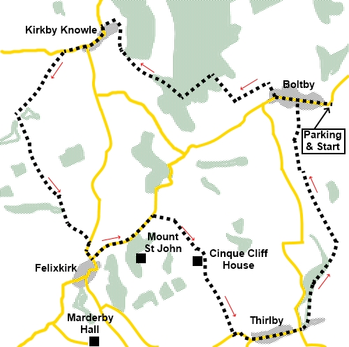
To view route as a dynamic Ordnance Survey map click here. Introduction: This walk from Boltby takes you via smaller hamlets of Kirkby Knowle, Felixkirk, about half way (where there is a good pub) and Thirlby. It is a useful walk in that there are various points where you could shorten the walk, say in the event of inclement weather or, if you wanted a much longer day out, it could easily be linked with my walk from Kilburn, at Boltby and Thirlby. Boltby is the larges of these villages, with an attractive main street. It is dissected by Gurtof Beck, which has a 17th Century Grade II listed bridge over it. This may have been a packhorse bridge or it may simply have been to help people over the beck when it flooded. Depending on the beck levels, you can walk along the road. At other times it might need fording. Kirkby
Knowle is much smaller but with a pleasant church. Although my route does
not pass it directly, as you walk on to Felixkirk and look back, on the hill
is a large house known as Kirkby
Knowle Castle, although it is shown on the OS map as Newbygill. This dates
back to the 13th Century when Edward I gave permission for one
Sir Roger Lascelles to build it. It has suffered fire and restorations over
the years. One claim to fame is that Mary Queen of Scots was a frequent
visitor, when a knight, Sir Thomas Rokeby owned it. The
approximate halfway point is Felixkirk, named after the church of St. Felix.
There is an excellent pub in the village, the Carpenters’ Arms and a bench
on the village green if you are looking for a picnic spot. Opposite the pub
is Howe Hill. This is either the site of an ancient barrow or a motte,
depending on which experts are correct, but it is a prominent mound. The final
village is Thirlby. There is not a great deal to say about this village
except that the famous vet and author
James Alfred Wight, better known as James Herriot lived here. The walk starts from Boltby. To
get there, turn north off the A170, just east of Thirsk. The turn is
signposted for Felixkirk, which you pass through first and Boltby. On
arriving at Boltby, pass straight through the village and as the road bends
sharp left, there is a rough lay-by on the right. Start: From the parking area (SE 494866), walk through the village, past the Boltby Trekking Centre. As the road bends left, fork off to the right following a fingerpost for “Gurtof House Private Road” (SE 489867). Immediately, go through the left hand gate and follow the stony track. A sign warns to keep dogs on a lead and that horses are loose (although I did not see any).
Arrive at a fingerpost, indicating a bridleway in all directions. Turn left. Soon, a blue arrow on the next gate confirms you are on the right route. Continue until your way is barred by a fence and turn right to follow it in the direction of another blue arrow. As you near a barn, go through a gate and follow the fence on the right. Blue arrows clearly indicate the way. Follow the edge of the trees up the hill and go through a gate before turning left, by a bench to follow another blue bridleway sign (SE 482869).
Stay on this path, ignoring a turn uphill (SE 475868) The path drops down to the edge of the trees, where you turn right to follow the fingerpost for Kirkby Knowle (note the footpath has been diverted to go anticlockwise round the farm buildings). Just past the farm buildings, turn left down to the road and turn left along it (SE 470874). At the road junction, turn right in the direction of Felixkirk. Pass the church and continue in the direction of Upsall.
About three hundred yards after the church, turn left off the road, over a stile, on to a footpath indicated by an old style green, metal footpath sign (SE 465871). Bear right to pass just to the right of a power pole and follow the path as it bends left. The path now follows the area between the fence and the hedge and is clearly not well walked. When the path opens into a field, follow the left hand boundary. The path briefly enters this field of crops, before turning left after a few yards (SE 460865) and crossing a small stream, after which it follows the left hand boundary of a very large cropped field. From here and the next fields, there are good views across the Vale of Mowbray.
Follow the left hand boundary to a right angle corner and at the corner go left. Follow the yellow arrow behind the bushes This leads to another cropped field and again, keep to the left hand boundary of the fields until you drop down to a stile, Turn left over it following a yellow arrow. The path crosses a small stream and bears left up the banking. In the next field, the path on the ground starts following the right hand boundary but after no more than a hundred yards, turn left across the field to another stile marked with a yellow arrow. Cross the stile and a two plank bridge before following what is a fairly obvious path on the ground. Go through a wooded area and emerge into a field to follow the left hand boundary. At the road, turn right into Felixkirk.
Follow the road round the bend, passing the village green and at the junction, either carry on a few yards to see the pub/village but here you follow the road sign for “Boltby 1¾ miles”. Follow the road for half a mile, passing the entrance to Mount St. John. At a double entry on the right, the left hand of which has a cattle grid, turn right, off the road (SE 475853). Follow the track until it divides (SE 478852). There is another cattle grid and a gate asking that you close it. There are good views to Sutton Bank along this section.
Follow the track down and just before Cinque Cliff House (the first house), turn left through a gate indicated by a yellow arrow (SE 480849). Follow the boundary hedge of the property and after going through a gate at the end of this first field, head for the bottom right hand corner of the field, where the bridleway continues through two closely placed gates and between the hedges. The route is obvious. Follow it to a tarmac lane and turn left, through Thirlby, keeping left at the road junction. After passing through the village, the main road turns left for Boltby. Turn off the main road, effectively straight on, along the no through road.
Pass the ford and as the road bends left, just beyond the ford, turn left following a public footpath fingerpost (SE 492841). The path is well defined until you enter a large open field. Follow the left hand boundary until you are within a hundred yards or so of the far side then bear right towards a stile in the hedge ahead. You will soon spot the yellow arrow guiding you to the route between the fence and the hedge. Arrive at a tarmac access lane to Tang Hall. Cross straight over following the public footpath fingerpost.
The path is well defined with tramples grass and stiles. The only tricky part is that when you get to a large drainage ditch on the left, you need to work your way along the left hand side to get to a gate with a yellow arrow indicating the way. I stepped over the low barbed wire fence to reach it. The path emerges in Boltby. Turn right to return to the car. If you need to buy any hiking equipment/clothing before your trip see the Hiking Store All information on this site is given in good faith and no liability is accepted in respect of any damage, loss or injury which might result from acting on it.
| | |||||||||||||||||

.jpg)
.jpg)
.jpg)
%20Good%20view%20at%20start.jpg)
%20Looking%20along%20Boltbys%20main%20street.jpg)
%20Packhorse%20Bridge%20Boltby.jpg)
%20Rhododendrons%20on%20climb%20out%20of%20Boltby.jpg)
%20View%20to%20Sutton%20Bank.jpg)
%20Far%20reaching%20view%20over%20Vale%20of%20Mowbray.jpg)
%20Church%20of%20St%20Wilfred%20Kirkby%20Knowle.jpg)
%20Kirkby%20Knowle%20Castle.jpg)
%20Carpenters%20Arms,%20Felixkirk.jpg)
%20View%20on%20way%20to%20Thirlby.jpg)
%20Rose%20covered%20cottage%20Thirlby.jpg)
%20May%20blossom%20near%20Thirlby.jpg)