
|
|
|
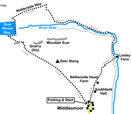
To view route as a dynamic Ordnance Survey map click here. Introduction: This walk from Middlesmoor to Scar House Reservoir provides some lovely views of Nidderdale and follows lower level paths on the outward journey than my Lofthouse to Scar House Reservoir walk, and is shorter. The walk is straightforward navigationally apart from one short section where you need to follow a dilapidated wall – see text. A somewhat hazy day rather spoiled the photos. Overall it is an easy walk but I graded the section up from the reservoir as just amber as it is quite a steep pull. There are picnic tables and toilets in the car park at the reservoir, with a short diversion. Scar House reservoir was very low after the recent droughts. Middlesmoor is a quaint, unspoiled hill village at the end of the main road through Nidderdale and looks as though it is unchanged for centuries. You only get there because that is where you are going! It is around 1200 ft high and one of the highest villages in Yorkshire. It has a Victorian church, St Chad’s, which is Grade II listed and a still functioning pub, The Crown. The Middlesmoor Bell Festival is held each year on the Saturday closest to St Barnabas’ Day (11 June) to commemorate the gift of the church bells from a Mary Anna Barkwith, as a memorial to her great uncle Simon Homer, who founded the school at Middlesmoor in 1803. A stone cross inside the church is said to be Anglo Saxon. Scar House Reservoir was built in the 1930s to supply water to Bradford in conjunction with Angram Reservoir higher up the valley and Gouthwaite lower down. Unusually, it has impressive crenellations making it quite an imposing creation. Half way along are a series of viewing steps which also make a handy picnic spot if it is not busy. The hill above the reservoir to the north is known as Dead Man’s Hill, the story being that three Scottish peddlers were murdered and buried in the peat and later discovered by peat diggers. This is remarkably similar to the legend I mentioned in my walk Lofthouse to Skypeland with Jenny Twigg and her daughter Tib, the route of which is not far away. I will not repeat it again here. The walk starts from a car park at the top of the village (free at the time of my visit). To get there, take the B6265 to Pateley Bridge and turn north just before or just after the river bridge, depending on your direction of approach. It is signposted for Ramsgill, Lofthouse and Middlesmoor. Start: Turn left out of the car park and after only a few yards, look out for a fingerpost on the left (set back a little). Turn left here following the direction for “Public Footpath for Limley 1¼ miles”. This refers to Limley Farm which is where you want to get to. Follow the fairly obvious footpath sticking more or less to the contour level.
Cross the broad track leading to Smithfield Hall (SE 093747) and head for the wood you can see ahead, where you join a broad track. Turn right along it (indicated by a yellow footpath arrow), passing Netherside Head Farm and stay on this track for just under half a mile. After
passing through a gate (SE
096755), turn right. Follow the path down the field, curving left to pass a
small copse of trees, crossing a stream, then turn right through a gated
stile. Bear
left following the footpath arrow, heading just to the right of the
diagonally opposite corner of the field. Cross
the stile and after a few yards, cross another on the left and go to the
gateway at the bottom of the field, following the arrow. You
should see the gate at the bottom of the next field. Here, cross the broad
track and go through another walkers’ gate. Head through the farm gate.
You are now at Limley Farm. Look
carefully for the yellow arrow pointing left through a gateway into the yard
of the first building, then through a gate in the left corner. Do not take
the other footpath straight ahead. Follow the path to what was a dry section of the River Nidd when I did the walk and continue along its left hand bank. You follow the course of the river for just over half a mile to a footbridge. This is quite hard to spot in the trees and would be easily missed. It is after a long left hand bend in the river.
Cross
the footbridge (SE 099767) and turn left to follow the river’s right hand
bank. You now follow the river for 1.2
miles, passing New Houses, identifiable by a mass of purple signs for
various buildings, where you join their drive for about a third of a mile,
before reverting to footpath. It is all pretty well marked by
gates/stiles/signs. Carry on
roughly following the river, avoiding any turns off until you get to Low
Woodale farm (SE 081771). Go straight through the farmyard and follow the
obvious track straight ahead (avoid the path going right). Pass Middle Woodale Farm and continue to follow the clear track. As you enter a rough pasture field, there is a dilapidated wall on the right (SE 078774). Follow this wall keeping to its left. This is important because if you wander away from this wall, you may miss the next direction point! When I did the walk, there was considerable bracken which obscured it.
Follow
the wall until you get to a metal farm gate, in a more robust wall, with a
walkers’ gate attached. Go through this gate and climb the hill beyond.
You may lose sight of any obvious path beyond the gate but as long as you
keep heading upwards (about 335°magnetic),
you will meet a broad stony track, part of the Nidderdale Way. It does not really matter at what point you meet this track (about SE 077776). Turn left along it, passing along by a woodland area.
Follow this track for three quarters of a mile, at which point you will be looking down on Scar House Reservoir.
Cross over one track which leads down to the reservoir house and down another to a junction where you turn left to the dam. Cross the dam (there are some handy stone steps half way along if you have brought a picnic) and at the end turn right.
After
about three hundred yards, just before a gate, turn left up a broad stony
track, lined initially with large boulders. This is a byway open to all
traffic so it is possible you may meet an odd vehicle – a couple of
scrambling bikes passed. It is signposted for Middlesmoor and leads all the
way back to the parking area. If you need to buy any hiking equipment/clothing before your trip see the Hiking Store All information on this site is given in good faith and no liability is accepted in respect of any damage, loss or injury which might result from acting on it.
| | |||||||||||||||||

.jpg)
.jpg)
.jpg)
%20Looking%20down%20Nidderdale.jpg)
%20Footbridge%20referred%20to%20in%20the%20text.jpg)
%20Looking%20up%20Nidderdale.jpg)
%20First%20sight%20of%20Scar%20House%20reservoir%20dam..jpg)
%20View%20up%20Nidderdale%20with%20Great%20Whernside.jpg)
%20Scar%20House%20reservoir.jpg)
%20Looking%20along%20Scar%20House%20Reservoir.jpg)
%20View%20east%20from%20the%20dam.jpg)
%20Looking%20along%20the%20dam.jpg)