
|
|
|
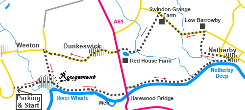
To view route as a dynamic Ordnance Survey map click here. Introduction: This walk from Weeton to Netherby is an easy stroll, ideal for a morning or afternoon ramble. I did the walk on a grey day in June, which did nothing for photographs but it turned out to be something of a wild flower safari as the blooms were prolific. The walk did have some surprising items of interest. The first was Rougement, an area of trees marked on the map as an antiquity of interest. As you enter the wood, you can just make out the remains of an ancient ditch. It transpires this is the remains of an ancient “ringwork”, a type of fortification dating back to Anglo-Saxon/Middle Age times. It was the residence of the Lord of the Manor of Harewood with a garrison and outbuildings until Harewood castle (now a ruin) was constructed in 1366. It was built of timber with an inner bailey of stone. On the approach to Rougement is an ancient packhorse bridge. The second interesting area is the remains of an old weir at Harewood which used to power the mill. The third area of interest is Netherby Deep. At this location in the 1930s, sand was trucked in from Bridlington to provide an artificial beach, so that poor families who could not easily get to the “proper seaside” had an alternative. There were even beach chalets, a caravan park and pub. The popularity of the site continues until the early 1960s. Hundreds of people could turn up. However in 1963, there was a tragic drowning of two twin boys who had gone swimming in the river at Netherby Deep where there are evidently treacherous currents. The popularity declined after the drowning, coupled with the rise of cheap, foreign holidays. All that remains is a deteriorating notice erected by the grandfather of the twins warning of the dangers. There is a bench here, which is about the only comfortable spot should you want to take a picnic. The walk passes close to the Harewood Estate so not surprisingly Red Kites proliferate, because the Estate released a number in 1999, as part of a conservation programme. The programme was a huge success and you will be unlucky not to see some of these magnificent birds. I was also lucky enough to see a heron near Harewood Bridge. As you approach Harewood Bridge, behind you on the left is a good view of Almscliff Crag and there are views along the valley to Otley Chevin on the return. The walk starts from Gallogate Lane out of the village of Weeton.This is a “loop” road and it is best to take the most easterly leg of the loop, off Main Street. Just under half a mile from Main Street, there is a grassy lay-by on the right hand side. The footpath starts virtually opposite this Start: From the lay-by (SE 289462), turn right and immediately left, following a public footpath fingerpost and follow the broad track.
As the track turns sharply right, go through a walkers’ gate and follow the left hand boundary for a hundred yards or so then bear slightly right to another gate at a packhorse bridge. Cross this and once through the following gate, bear slightly left, heading towards the left hand side of the trees ahead. As you get closer to the trees, you will see a walkers’ gate, to take you into the woods (SE 294463). This is the area of Rougement.
Follow the obvious path through the woods, passing an information board. Ignore the path off to the left here. This will be your return route. When the path divides, close to the left hand edge of the trees, fork left and walk along the edge of the trees.
The path drops down some earth steps to follow the course of the river. Follow the river to the old weir and Harewood Bridge, where you emerge at the A61 road, via a house drive (SE 312461). Cross the road and turn left, then first right along a no through road, passing Bridge Court.
The tarmac road becomes a stony track, then an earth footpath by the river. The path leaves the river to join a tarmac lane at Netherby (SE 333468), a few yards past Netherby Deep and the notice referred to in the introduction. Turn left.
When the lane turns sharp right, continue straight ahead on the broad track, following a blue bridleway arrow. After just under a quarter of a mile, look out for a short wooden bridge on the right. Cross and follow the obvious path up to the road. Turn left along the road for three quarters of a mile. At Swindon Grange Farm, stay on the road until just after the brick, detached house. Turn left here on to a footpath (SE 319477). Follow the left hand boundary for two fields. On exiting the second field, aim just to the right of the summit of the field ahead. Head for the power pole at this point and continue in that line. You will eventually see the stile arrangement. Cross the stile and somewhat rickety bridge and turn right, to aim for the gap in the trees. The path passes the right hand side of an attractive pond by Red House Farm and meets the A61 (SE 310470). Cross and follow Weeton Lane for one mile.
At a road junction by a bend in the road, recognisable by having a grass triangle “island”, turn left to follow a public footpath fingerpost (SE 295470). This path, with good views along the valley to Otley Chevin, takes you down to the information board at Rougement. Turn right here to retrace your steps to the car.
If you need to buy any hiking equipment/clothing before your trip see the Hiking Store All information on this site is given in good faith and no liability is accepted in respect of any damage, loss or injury which might result from acting on it.
| | |||||||||||||||||

.jpg)
.jpg)
.jpg)
%20View%20across%20the%20valley%20near%20the%20start.jpg)
%20Old%20packhorse%20bridge.jpg)
%20Plaque%20at%20Rougement%20Castle.jpg)
%20Red%20Campion%20against%20Jack%20By%20The%20Hedge.jpg)
%20Red%20Kite.jpg)
%20Old%20Weir%20near%20Harewood%20Bridge.jpg)
%20Heron%20at%20Harewood%20Bridge.jpg)
%20Almscliff%20Crag.jpg)
%20Harewood%20Bridge.jpg)
%20Wild%20roses.jpg)
%20Prickly%20Comfrey.jpg)
%20Bush%20Vetch.jpg)
%20Birdsfoot%20Trefoil.jpg)
%20Poppies%20growing%20in%20a%20barley%20field.jpg)
%20Debris%20from%20the%20winter%20floods.jpg)
%20View%20across%20the%20valley.jpg)
%20Old%20Buildings%20at%20Wharfe%20Hill%20Farm.jpg)
%20Pond%20at%20Red%20House%20farm.jpg)
%20Looking%20along%20the%20Wharfe%20Valley%20to%20Otley%20Chevin.jpg)