
|
|
|
To view route as a dynamic Ordnance Survey map click here. Introduction: This walk, starting in the attractive village of
Embleton takes you through countryside to the north end of the gorgeous
Embleton Bay. It then follows the bay to the spectacularly positioned
Dunstanburgh Castle and then a short distance further along the coast before
returning via country footpaths to Embleton. Embleton
has a convoluted past and even the origin of its name is uncertain having at
one time been called Elmesdun,
first recorded in around the year 1200. The “dun” part is from the Old
English for ‘hill’ but the rest is a little vague. In 1255, the Embleton
Estate belonged to the Earl of Leicester. It then passed to the Earl of
Lancaster, then to a Leeds man. It remained a distinct estate until the
early part of the 20th Century. During
something like 300 years from the 12th Century, Embleton was
drawn into Scots/English conflicts and the War of the Roses and peace only
resumed in the 16th Century. In
more recent times, a quarry on the north side of the town was a major source
of employment. It closed in 1961. In the surrounding area, farming is an
important industry. The
village has a number of listed buildings and has been declared a
Conservation Area. The
route of the walk takes you past Dunstanburgh Castle. Its construction was
started in 1313 by the Earl of Lancaster. It is
now owned by the National Trust, maintained and managed by English Heritage.
Although it is well ruined, nevertheless you get a good idea of just how
magnificent it must have been from what is left and the remainder of the
perimeter walls. Sitting high on a promontory overlooking the sea, it must
have been an impressive sight to all who approached it by land or sea. This walk could easily be combined with my The
Newtons walk if you wanted a longer excursion. The
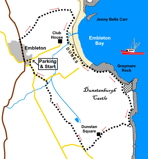
walk starts from the village of Embleton where there is on street parking.
To get to Embleton, turn off the A1 just north of Alnwick on to the B1340
signposted for Alnwick, then follow signs for Seahouses and Embleton,
eventually joining the B1139, which takes you into the village. Turn at the
Dunstanburgh Castle Hotel for Front Street. Start: Walk
to the bottom of Front Street and turn right along the main road past the
Dunstanburgh Arms pub. Follow until the pavement runs out then continue along the wide verge on the right hand side for about a third of a mile. Look out for a fingerpost for “Low Newton by the Sea 1½ Miles” and “High Newton by the Sea 1¾ miles” (NU 230232). Follow
the direction of the arrow. The path goes straight for about three hundred
yards then kinks left. With any luck, the route through the crops will have
been well trodden when you do the walk but if in doubt, at the far side of
the field is a hedge and to its left, there is a short section of fencing.
The left of this fencing is your aiming point (NU 233234). At
the fence, continue towards the sea, following the right hand boundary of
the next field. As
you get to the corner of this next field, follow the boundary round the
corner for a few yards and cross a stile on the right, then follow the right
hand boundary in this and the following field. When the boundary turns sharply right, keep straight ahead towards the sea. The path is obvious.
You
briefly skirt the edge of a golf course before arriving at a three way
fingerpost (NU 243239). Turn right to follow the English Coastal Footpath sign. The path runs along the landward side of Kittycarter Burn but then the official route of the English Coast Footpath runs behind the dunes. Nothing wrong with the path itself except that you cannot see the sea and the beaches. Therefore after crossing a footbridge (NU 242230), head up on to the dunes where there is a narrow but clear footpath.
Follow
this for half a mile. There is then a clear path through to the beach. I
walked along the beach here and stopped for a picnic but if the tide was
that far in, there is the option to continue along the dunes of come a
little further in land to turn left along the ‘official’ Coast path. Assuming you walk along the beach, follow it almost to the mass of rocks then cut back in to the Coast path and turn left.
Follow the path around the mound on which stands Dunstanburgh Castle. Once round the corner, people meander pretty much where they want, however the path soon shows the clear direction to follow.
You will meet a walker’s gate next to a five bar gate by a short section of wall. Turn right here to follow a clear path across the grass up the field to a gate. This path does not strictly follow the official route on the OS mop but is clearly the way everyone goes and even looked mowed to encourage that route.
Cross
a stile and follow the left hand boundary beyond. The
path heads down over a short cobbled section to two gates. Go through the
left hand gate across the field, following the yellow arrow and the left
hand boundary to the farm. At
the farm, turn left and follow the lane. At
the ‘T’ junction, turn right and follow the lane until it bends sharply
left. On the bend, turn off in the direction of a fingerpost for “Dunstan
Steads 1½ miles” “Embleton 1¾ miles”. Briefly
follow the right hand boundary, then the path continues across the strip of
rough ground between the two fields. At
the end of the strip, go through a walkers’ gate to follow the left hand
boundary of the fields beyond. Pass
a campsite and continue to a band of trees. Cross a stile into the trees and
turn right. You
will soon reach a junction of paths with two way yellow arrows on a post
marking the spot. Turn right. Look
out for a footpath on the left (NU 238218), with a sign on the gate warning
there is no access to Eleanor’s Byre or Ember’s Pizza. Go through the
gate and straight across the field to another gate. Through this, follow the
path as it curves right, then left to a track. The
track will take you to a road. Turn left then right at the junction to
return to Embleton. As you come into the village and the main road bends
left, keep straight ahead to return to Front Street. If you need to buy any hiking equipment/clothing before your trip see the Hiking Store All information on this site is given in good faith and no liability is accepted in respect of any damage, loss or injury which might result from acting on it.
| | |||||||||||||||||

.jpg)
.jpg)
.jpg)
%20View%20to%20Dunstanburgh%20Castle.jpg)
%20View%20to%20Low%20Newton%20by%20the%20Sea.jpg)
%20Huts%20at%20Low%20Newton%20by%20the%20Sea.jpg)
%20Looking%20over%20Embleton%20Bay.jpg)
%20View%20to%20Low%20Newton%20by%20the%20Sea.jpg)
%20View%20through%20the%20dunes.jpg)
%20South%20end%20of%20Embleton%20Beach.jpg)
%20Old%20and%20Older%20fortifications.jpg)
%20Breakers%20at%20Castle%20point.jpg)
%20Remains%20of%20corner%20tower%20art%20Dunstanburgh%20castle.jpg)
%20Imposing%20entrance%20of%20Dunstanburgh%20Castle.jpg)
%20View%20south%20from%20Castle%20Point.jpg)
%20Looking%20back%20to%20Dunstanburgh%20Castle.jpg)