
|
|
|
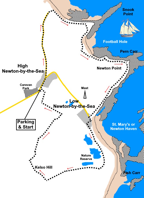
To view route as a dynamic Ordnance Survey map click here. Introduction: This walk takes you along the coast from High Newton-by-the-Sea to Low Newton-by-the-Sea, hence the title of the walk. It follows lovely path across the sand dunes. The official English Coast Path appears to be at a lower level at the rear of the dunes but by following this, you would not have sight of the sea. The path along the dunes is obviously well walked and marked on the OS map as “St Oswald’s Way”. From the path you get great views over Beadnell Bay and pass and attractive cove and rocky point with later views down the coast to Dunstanburgh Castle. High Newton looks a well to do place with an upmarket ‘bistro pub’, the Joiners Arms. Low Newton (sometimes known as Newton
Seahouses) was built in the early 19th century as fishermen's cottages. It
is now mostly owned by the National Trust. It is particularly noted for the
picturesque open square of cottages around a green. The Ship Inn at the back
has its own microbrewery. Much as I was craving a trial, the place was so
busy that I gave up! The village has a great sandy beach which
continues round to Embleton Bay. After the centre of Low Newton you come to an
extensive collection of huts built on the dunes. These were built in the
1930s and no doubt would never get planning permission today. They are a
random mix of shapes and sizes, some look to have been extended over the
years. They are occasional holiday homes only and the water is turned off
for the winter. There is no road access so everything has to be lugged over
the coastal footpath. There is no electricity either though I notices one or
two with solar panels. I suspect the huts are virtually impossible
to obtain. Whilst browsing, I came across a very basic one which was for
sale at £85,000 and that was in 2022! This walk could easily be combined with my Embleton
to Dunstanburgh Castle walk if you wanted a longer excursion. The walk starts from a car park at High Newton-by-the-Sea. To get there, turn off the A1 on to the B6347 for Christon Bank. At Christon Bank, after crossing the railway line, the road becomes the B1340. Continue to follow this until you see a sign for Newton-by-the-Sea and the Joiners Arms. Follow the lane and look out for a free car park on the right, from where the walk starts and finishes. Start: From High Newton Car Park, exit into the lane and turn right.
At the village green, take the left fork passing the Joiner’s Arms and continue along the lane until you reach another car park on the right. Here the lane bends left but you keep straight ahead through a gate top join the coast path along the top of the dunes. Turn right. At this point you are along the southern end of Beadnell Bay, with a great view across the sand to Beadnell itself.
You reach a rocky promontory Snook Point (NU 241259) followed by the attractive Football Hole bay. Continue to follow the obvious footpath round Newton Point to arrive at Low Newton-by-the-Sea where there is an attractive ‘square’ with a green and The Ship Inn.
At Low Newton, take the path to the right of the outside of the square, following a fingerpost for “English Coast Path” and “Toilets 70 Yards”, then turn left in front of the toilets. Follow the main path through the nature reserve until you come to a three way fingerposts. Ignore the English Coast Path fingers and follow the Public Footpath direction (to the right of the sign for the “Dunstanburgh Golf Course”).
The path follows the right hand boundary of the golf course. At
the next junction of paths (NU
231237), turn right following a yellow footpath arrow and head for the small
hill ahead. You cross a large field. At the far side, keep to the right of the fence and follow it along. You pass a picnic table next to a World War II pill box, from where there is a good view across to Dunstanburgh Castle.
As the path rises to its crest, look out for a narrow path leading to the summit of the hill. Note this is slightly before where it is shown on the OS map which has not caught up with a diversion at the time I did the walk.
Follow
the path along the summit of the hill, then down a slight dip before rising
again. A post with a yellow arrow indicates the continuation direction. A
sign below the arrow indicates the path has been legally diverted. The
route from here is a well defined path, either fenced in or clear tracks and
marked with yellow arrows. Follow it back to the car park. As you get to the
village, look out for a fingerpost for “Newton-By-The Sea
Mixed use Access”. Here there is a short rough path back into the
car park. If you need to buy any hiking equipment/clothing before your trip see the Hiking Store All information on this site is given in good faith and no liability is accepted in respect of any damage, loss or injury which might result from acting on it.
| | |||||||||||||||||

.jpg)
.jpg)
.jpg)
%20Village%20Green%20at%20High%20Newton.jpg)
%20Beadnell%20Bay.jpg)
%20Rocks%20at%20Snook%20Point.jpg)
%20Beach%20at%20Football%20Hole.jpg)
%20Coast%20Path%20At%20Newton%20Point.jpg)
%20Former%20LORAN%20station.jpg)
%20Rocks%20at%20Lobster%20Carr.jpg)
%20Bay%20at%20Low%20Newton.jpg)
%20Low%20Newton%20By%20The%20Sea.jpg)
%20Lake%20at%20Low%20Newton%20Nature%20Reserve.jpg)
%20Huts%20on%20the%20dunes.jpg)
%20Pill%20box%20and%20picnic%20table%20on%20way%20to%20Kelso%20Hill.jpg)
%20View%20to%20Dunstanburgh%20Castle.jpg)
%20Looking%20back%20to%20Low%20Newton.jpg)