|
Ilkley
to Burley-in-Wharfedale
|
Starting
point and OS Grid reference:

Ilkley
train or bus station – (SE 118476). Parking is also available in Ilkley.
|
Ordnance
Survey Map
OS
Explorer 297 – Lower Wharfedale and Washburn Valley.
Buy this map from
List
of OS Maps
Note: If you use OS Maps on-line, you can download this route via this
link.
| |
Distance: 4.8 miles
| |
Traffic light rating:

(For explanation see My
Walks page)
| |


For advice on .gpx files see
My
Walks page
|

Click
the PDF logo above to give a printable version of this walk without the
photos.
|
To
view route as a dynamic Ordnance Survey map click here.
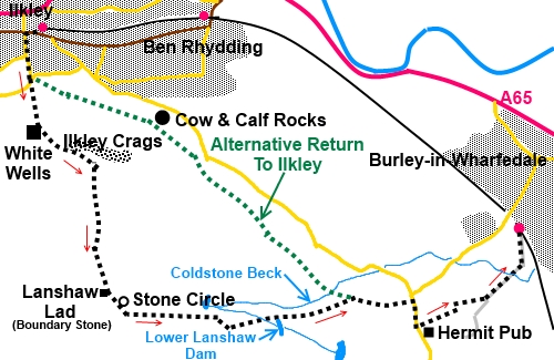
Introduction:
This short walk from Ilkley takes you to within a few feet of the
highest point on Ilkley Moor, with 360° views over Lower Wharfedale and
Airedale before crossing Burley Moor. Both moors are part of the larger
Rombalds Moor area.
The walk has the bonus of providing a lunch
opportunity at The Hermit pub at Burley Woodhead. It is also an ideal walk
for public transport as it starts from the adjacent rail and bus stations in
Ilkley and terminates at Burley-in-Wharfedale railway station. If buses are
preferred from Burley, stops are only half a mile away in Burley village
centre. If a circular walk back to Ilkley is wanted, a return path along the
edge of the moor is available.
The walk passes the Twelve Apostles Bronze
Age stone circle and reservoirs on Burley Moor. There is a good chance of
seeing assorted wildlife. I saw a heron, curlews and oyster catchers when I
did the walk.
The moors are a well visited and well walked
area and there are many paths/tracks which this use has created, not all of
which are public footpaths as defined by Ordnance Survey.
The walk is generally easy with a bit of a
steep climb to get to the top of Ilkley Moor. Much of this is up steps.
Start:
Exit the main entrance of either station (SE 118476), cross the road and
turn right then first left up Wells Road. Carry on up the road as far as a
cattle grid, going through the walkers’ gate alongside (SE 118472). Go
left immediately and take the path past the boating/paddling pool to the
steps. Climb these and continue along the tarmac path.
The tarmac does not last long before the path
reverts to standard country footpath type! At a ‘Y’ junction of paths,
take the left fork climbing some rough steps. Ahead of you is the white
building of White Wells – head towards this. White Wells is a bath house
built by Squire Middleton in the 18th century for the local
people, with an interesting plunge pool to see, if it is open (flags flying
is a good sign).
%20White%20Wells.jpg)
%20View%20over%20Ilkley%20towards%20Beamsley%20Beacon.jpg)
On reaching White Wells, pass it on the left
then walk along the back of the building. Here you will see a fingerpost for
the Millennium Way. Turn left to follow it (SE
118468).
Follow the broad track from this fingerpost
and when it divides, the Millennium Way going left, take the right fork,
climbing yet more steps above Ilkley Crags.
%20Millennium%20Way%20path%20from%20White%20Wells.jpg)
%20Cotton%20Grass%20on%20Ilkley%20Moor.jpg)
Shortly after the top of the steps you reach
a crossroads of paths (SE 124464). Go straight on.
Eventually the rough path gives way to
erosion prevention Yorkshire Stone paving. Follow this to the crest, passing
a rectangular boundary stone on your right known as Lanshaw Lad (SE125452),
which marks the boundary between Ilkley and Burley Moors.
%20Lanshaw%20Lad%20Boundary%20Stone.jpg)
%20Twelve%20Apostles%20Stone%20Circle.JPG)
Pass another paved path going off to the
right and you soon come to the Twelve Apostles stone circle (SE 126451).
This is set in a superb vantage point with 360° views over Wharfedale and
Airedale. In the distance to the south south-east (162°) is the Emley Moor
transmitter and Ferrybridge and Drax power stations can also be seen. To the
north east, the white domes of the Menwith Hill “listening station” are
clear.
Continue on the path for about 150 yards
beyond the stone circle then turn left along a broad track (SE 127450).
You pass above High Lanshaw Dam, the first of
a series of three reservoirs on Burley Moor. After passing some large
boulders (SE 136449), branch off to the left just before the shooting hut,
head downhill following the path towards the middle reservoir, Lower Lanshaw
Dam (note you do not go as far as the third which is Carr Bottom Reservoir).
%20Shooting%20Hut,%20Burley%20Moor.jpg)
Follow the path by the left of Lower Lanshaw
Dam, passing another boundary stone to your left. Do not take the path down
the little valley which contains Coldstone Beck and avoid a smaller path
going off to the right after a few yards.
%20High%20Lanshaw%20Dam.jpg)
%20Otley%20Chevin%20From%20Burley%20Moor.jpg)
Burley-in-Wharfedale village comes into view.
%20Burley-in-Wharfedale.jpg)
The path forks with a broad grassy track
going off to the right. Keep left.
When you get to a crossroads of tracks marked
with a post bearing a Millennium Way sign (SE 148451), keep straight ahead
but note this point, as if you plan to walk back to Ilkley, the left turn
here (or right on your return from the pub) is the moor edge path.
You exit Burley Moor at Burley Woodhead, on
to the road by a former school converted into a house. Turn right following
the fingerpost direction for “Dalesway Link, Leeds and Ebor Way”. The
Hermit pub is on the left after 300 yards.
%20The%20Hermit%20pub.jpg)
The onward route to Burley station leaves The
Hermit car park from its left hand corner (as viewed from the road). There
is a fingerpost for “Burley” but this is sometimes obscured by the
shrubbery. The start is the drive to a house. Cross the yard and follow the
path between a hedge and a fence.
Cross another path (identified by a narrow
stile a few yards to the left) (SE 155449) and keep straight on. The path
may not be significantly worn and easy to see but just keep to the left of a
line of dilapidated concrete fence posts. Enter the trees through a
walkers’ gate.
Follow the line of the trees and when they
peter out, follow the boundary line down to a white walkers’ gate. The
path splits but joins again after a few yards. Cross a small stream then
follow the line of stiles to exit into Hag Farm Road. Turn left and follow
this to the train station. If you want buses, follow Hag Farm Road to its
end and turn right and follow Station Road down to Burley-in Wharfedale
village centre.
If you are walking back to Ilkley, from The
Hermit, return to the crossroads of paths mentioned above and turn right.
Cross Coldstone Beck and climb the other side and stay on the left of the
stone wall. Stay on the main path as it follows the edge of the moors until
you reach the unmistakable Cow and Calf Rocks.
%20Cow%20and%20Calf%20Rocks.jpg)
As you pass above the Cow and Calf Hotel,
look out for the large rocks on the right which is where the Cow and Calf
Rocks are (SE 130467). Follow the obvious path descending back to Ilkley.
If you need to buy any
hiking equipment/clothing before your trip see the Hiking
Store
All information on this
site is given in good faith and no liability is accepted in respect of any
damage, loss or injury which might result from acting on it.
|


.jpg)
.jpg)
.jpg)