|
Shipley To Ilkley
Starting point and OS Grid reference:

Shipley
train station (SE
150374)
|
Ordnance Survey Map
OS
Explorer 297 Lower Wharfedale and Washburn Valley and OS
Explorer 288 Bradford and Huddersfield.
Buy these maps from
List
of OS Maps
Note: If you use OS Maps on-line, you can download this route via this
link.
| |
Distance:
8.3
miles
|
Date of Walk:
5
September 2015
| |
Ascent:
Descent:
See Walking Time Calculator
|
1213ft (370m)
1135ft (346m)
| |
Traffic
light rating: 
(For explanation see My
Walks page)
| |


For advice on .gpx files see
My Walks page
|

Click
the PDF logo above to give a printable version of this walk without the
photos.
|
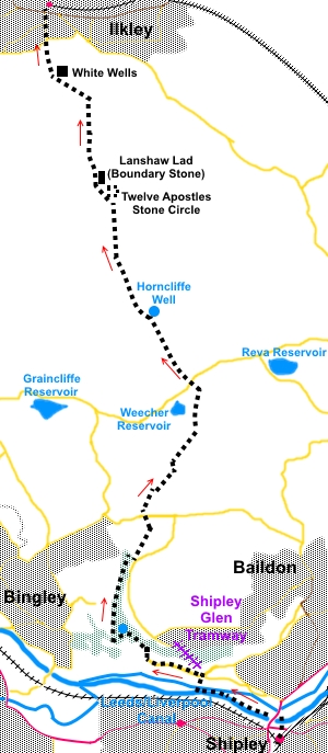
Introduction: This linear walk
is ideal for anyone who wishes to use public transport as it starts from
Shipley and ends in Ilkley, both of which are well served by trains and
buses. Trains link the two directly. The walk passes a number of interesting
features but my main reason for doing the walk when I did was to view the
blooming heather on the moors. The walk crosses Bingley, Burley and Ilkley
Moors (each part of the all encompassing Rombalds
Moor) and provides fine
views over the moors themselves and across Airedale and Wharfedale.
The
walk begins from Shipley rail station, with a short section by the
Leeds/Liverpool canal, before crossing Roberts Park and progressing through
the woodland of Shipley Glen to Bingley Moor.
Roberts
Park was originally built for Sir Titus Salt (of Saltaire fame) and known as
The Peoples Park or Salts Park. In 1891, it was purchased by Sir James
Roberts, who renamed Roberts Park as a memorial to his son Bertram and
donated eventually to Bradford Council.
Across
the road from the park, is The Shipley Glen Cable Tramway, the oldest
working cable tramway in Great Britain, apart from some cliff systems. It
dates from 1895 when it would have cost 2 old pence for a round trip. It is
open Saturday and Sunday afternoons, according to its website.
Once
on the moors, the route passes Horncliffe Well, which was first mentioned in
records in 1273. It was then a free flowing well which never dried even
after droughts and at one time simply opened on to the moor over an old
stone. It was said to have healing powers and was no doubt a boon to those
making their way across the moors. Unfortunately, after Yorkshire Water
acquired it, the visible well disappeared beneath a manhole but the water
can clearly be heard rushing below. An old stone sign marks its position,
after crossing a stone stile which includes an unusual boundary stone. This
mentions one Thomas Pulleyn, who was at one time the Lord of the manor
living at Burley Hall (Burley-in-Wharfedale). He died in 1759.
To
view route as a dynamic Ordnance Survey
map click here.
Beyond
Horncliffe Well, the walk passes The Twelve Apostles Stone Circle. It is
believed there were originally between 16 and 20 stones, erected some 4,000
years ago but over the years, various “restorations” have resulted in
the 12 we see today. The purpose of the circle is uncertain but could have
related to religious ceremonies and/or astronomical observation.
Close
to the stone circle is Lanshaw Lad, a large, 19th century,
rectangular stone marking the boundary between Ilkley and Burley parishes.
There are several letters and dates carved on it.
Finally,
the famous White Wells makes an interesting stop for refreshment and to see
the bath house - when open. Sometimes regarded as of Roman origin (though
without any evidence!), the bath you see was actually built in the second
half of the 18th century.
As
stated above, the walk starts at Shipley train station. Note there are no
public toilets here. Maybe if enough people ask where the toilets are,
Network Rail would get the message! It is ridiculous that a station where
people wait to change train lines have none.
There
are toilets in Roberts Park at the café (when open) and at White Wells.
Refreshments are available at both.
Please
note parking in the centre of Shipley is barely an option. If wanting to use
a car, I suggest locating Coach Road, along which the walk passes and
parking there. The first part of the walk can then be used to return to the
car.
Somewhat
confusingly, you will see various signs for differently named walks on this
route, not least the Airedale Greenway, Dalesway Link, Millennium Way and
Dales Highway. Various sections of these walks overlap. I therefore refer to
these walks at various points.
Start: Shipley
Station (SE 150374) has a number of exits which can be confusing if you do
not know it. My advice would be to take the main exit next to the booking
office. Walk down the access road to the main A657. Turn left but
immediately cross the main road via the traffic light controlled crossing.
Immediately opposite is a car park. If you look closely to the left of the
buildings (next to what was a carpet shop when I did the walk), there is a
public footpath sign.
Follow
this sign to cross the canal, then turn left (west) along it (SE 151378).
This could be described as “right” once over the bridge due to the way
the exit turns.Follow the canal
under the main A6038 (Otley Road), following the signs for Saltaire. This
part of the canal is part of the Airedale Greenway.
%20Swans%20on%20the%20Leeds%20Liverpool%20canal.jpg)
Stay
on the canal until you get to the Boathouse Inn. Cross the footbridge on the
right over the river Aire into Roberts Park (SE 139382). In the park, follow
the perimeter path anti-clockwise until you get to a gateway, just to the
left of a large shelter where there is a lot of information about the area
and the park itself. Go through this gateway on to the road. If you want to
see the Shipley Glen Tramway, you need to turn right here for a few yards
but the route goes left along the road, passing Titus Salt School.
After
half a mile or so, look out for a stone cottage on the right hand side and a
nearby shop. Pass both of these and a hundred yards further on, turn right
to follow a public bridleway and Dalesway Link sign (SE 132386). There is an
information board at the turn which tells about “The Coach Road” (along
which you have been walking) and various other local facts.
Walk
up this track for about 150 yards then take a clear left turn. The path goes
into the woods.
There
are a number of paths which have been created by wandering walkers and it is
difficult to describe the correct route. The path passes beneath a boulder
field - up to the right. The main path is fairly level to begin with but
eventually it starts to curve clockwise and upwards. However before heading
in this direction, look out for a dam (Crag Hebble Dam) below you to the
left. This in itself can be difficult to spot through the trees as it is
covered with green algae (or was when I visited). However, you need to find
it because the route crosses the beck (Loadpit Beck) at the dam (SE 129389).
After crossing the
beck, keep straight ahead on the broad climbing track, identifiable by the
row of cobbles which runs up its centre. Pass and ignore an old kissing gate
on the left.
When the path
levels out slightly, just before a straight line of rectangular stones
across the path for drainage, turn right through a gap in the wall (SE
128389). Follow the path through the trees, curving left at the corner of a
wall by an old stone sink.
The path now
generally follows the left hand edge of the trees, for over half a mile.
Below you to the right you may hear the trickling on Loadpit Beck at the
bottom of the Glen. Eventually, as you near the top of the Glen and start to
catch glimpses of the stream, the path forks. Take the right hand fork down
to a castellated stone bridge over the Loadpit Beck, where it is joined by
Glovershaw Beck (SE 129401).
%20Looking%20over%20Shipley%20Glen.jpg)
%20Bridge%20over%20Loadpit%20Beck%20shipley%20Glen.jpg)
Cross
the bridge, after which the path splits into three. Take the left hand path.
You reach a fingerpost pointing right for “Millennium Way”. Here, turn
left, off the main track, on to a narrower path which follows the course of
Glovershaw Beck.
%20Heather%20above%20Shipley%20Glen.jpg)
Follow this path
until it exits into a road via an awkward slit stile, just by the road sign
for Eldwick. Cross straight over the road (SE 132406) and up the drive for
Golcar Farm and Willowfield, following the bridleway fingerpost for
“Dalesway Link” and “Millennium Way”.
At Golcar Farm,
there are three paths. Left is the Dalesway Link and to the right a path
over a wooden stile, neither of which you want! Keep straight ahead on the
middle path (Millennium Way). In the next field, follow the right hand
boundary.
Confusingly, the
route is also marked by arrows for the “Dales Highway”, a 90 mile walk
from Saltaire to Appleby in Cumbria. We almost
follow this now to White Wells on Ilkley Moor but the Dales Highway route
involves walking along a section of the moor road between Hawksworth and
East Morton. This is a fast, busy, narrow road and very unpleasant/dangerous
to walk along. My route avoids this.
Follow the field
round until you reach a wooden stile. Over this, turn left.
Next, turn left
through a metal farm gate onto a broad track which is a horse gallop. Go
straight ahead following the Dales Highway arrow. At a crossroads of
gallops, go straight ahead. There is a trodden path just to the left of the
gallop itself which might be a safer alternative!
At the next fork,
go left, passing under some power lines and almost immediately, fork right
off the gallops, soon passing another Dales Highway arrow.
Walk straight ahead
past Birch Close cottages and follow the drive.
When reaching the
tarmac, turn left (SE 139408).
As the metalled
track turns left towards the embankment of Weecher Reservoir, at a ‘T’
junction, we leave the Dales Highway to avoid the road. Go fractionally
right and through a slit stile on the left (SE 138420). This almost faces
you at the junction. Down the steps at the far side of the stile, cross the
stream via a metal bridge, then go over another stile.
The path may be a
little indistinct but head for the diagonally opposite corner of the
field where there is a stone stile. Cross this and follow the right hand
boundary initially. As the wall kinks right, at a gateway, keep straight on
to follow the wall ahead, to the road.
Cross with care and
go through a stile following the direction of a public footpath fingerpost
across the moor on an obvious path (SE 138425).
%20Heather%20on%20Hawksworth%20Moor.jpg)
%20Footpath%20leading%20to%20Horncliffe%20Well.jpg)
The path rises
gently for just over half a mile, to meet a wall at a stile marking
Horncliffe Well (SE 132433). The route continues straight ahead, not over
the stile but it is worth going over briefly to look at the stone marker for
the well and to examine the boundary stone which is part of the stile. There
are the remains of a building too.
%20Stile%20to%20Horncliffe%20Well.jpg)
%20Horncliffe%20Well%20marker.jpg)
Returning to the
original route. Pass through a walkers’ gate where a sign informs that you
are entering Burley Moor.
%20View%20to%20Otley%20Chevin.jpg)
At
SE128443, join a broad track by a large round topped milestone and turn
right. (You have to look at the rear of the stone to see the writing. There
is also a bench mark used at one time by Ordnance Survey to measure
altitudes, relative to known exact heights). Looking behind you, there are
good views across the Aire Valley and in good visibility, the Emley Moor
transmitter can clearly be seen on the horizon.
%20Milepost.jpg)
At
a junction of tracks, turn left.
Arrive
at the Twelve Apostles stone circle and just beyond, the Lanshaw Lad
boundary stone (SE 125452). Follow the descending
path to the right of Lanshaw Lad. The path is now extensively paved.
%2012%20Apostles.jpg)
%20Lanshaw%20Lad.jpg)
%20Paved%20path%20leading%20towards%20Ilkley.jpg)
After
crossing a small stream, the path forks. Go left.
You
arrive at a crossroads of tracks from where there is a good view of Ilkley
and the Wharfe Valley. Go straight on.
%20Approaching%20Ilkley.jpg)
As
you start to descend a rougher section of track, part man made steps and
part rocks, the buildings of White Wells appear below. Continue to follow
the path down to them. Have a look at the bath house if open.
%20White%20Wells.jpg)
%20Bath%20at%20White%20Wells.jpg)
From
White Wells, there are a number of choices of paths to Ilkley. My choice was
to cross in front of the buildings and take the small path down from the
front left hand side of the buildings (as viewed from the front).
This
path brings you down some steps by the boating pool to Wells Road (SE
118472). Turn right here and follow the road down into Ilkley. This brings
you out virtually opposite the train and bus stations.
If you need to buy any
hiking equipment/clothing before your trip see the Hiking
Store
All information on this
site is given in good faith and no liability is accepted in respect of any
damage, loss or injury which might result from acting on it.
|


.jpg)
.jpg)
.jpg)