
|
|
|
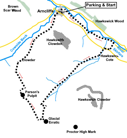
To view route as a dynamic Ordnance Survey map click here. Introduction: This must be one of the best walks in the Yorkshire
Dales. It takes you from the pretty village of Arncliffe in Littondale to
Parson’s Pulpit, with a pleasant stroll beside the River Skirfare to
finish. If
asked what is my favourite Yorkshire Dales walk, it tends to be the last one
I did, with the decision influenced by the nature of the weather but that
aside, this truly is a stupendous walk with fabulous pretty views which show
Littondale at its best and long distance views elsewhere. Highly
recommended. A
further plus from my point of view is that this is a quiet, peaceful walk. I
met no one on the entire route, until near the end when I returned to
Littondale. The
name of Arncliffe derives from Norse for Eagle’s Cliff’ and one can
easily imagine birds of prey spying out their victims from the limestone
ramparts of the valley sides. It is a lovely spot with a village green. Its
main claim to fame is that it and the pub were used at one time as the set
for the TV series Emmerdale (then Emmerdale Farm) but this is now so long
ago as to have ceased relevance. The
walk begins along what is named on the map as Monks Road, believed so called
because it was used by the monks from Fountains Abbey going to Malham,
though it seems a bit of a detour! This path follows top of the steep valley
along which flows Cowside Beck. The views start as soon as you start to
climb with the dry stone walls of Littondale etching their patterns on the
landscape. As you climb the views expand. As
you get to the area marked as Dew Bottoms on the OS map, my route then turns
more south, leaving recognised Rights of Way to make use of Access Land, to
visit Parsons Pulpit. There is therefore some overlap with my Parsons
Pulpit and Proctor High Mark walk. However, this route to it is much
more straightforward to navigate as there is a wall to guide you. There is
an easy climb over a wall. The views from Parsons Pulpit are superb and make
the effort worthwhile. Pausing
to investigate a glacial erratic, looking like an escapee from the Norber
Erratics, which I confess I did not know was there before, the route
then turns back to Littondale. Once again the views of the valley and its
limestone outcrops are fantastic. Once
back in the valley, the route then ends with a pleasant riverside stroll
back to Arncliffe where as a bonus, ‘refreshment’ can be obtained at the
Falcon Inn (check opening times to avoid disappointment). The
start of the walk up Monks Road is steep, hard work I hovered between a red
and amber marking but plumped for red in the end. The start of the ‘off
piste’ section is also quite hard; more because of the fairly long grass
rather than the steepness, though in places, a quad bike seemed to have gone
before and flattened some of it. The
walk starts from Arncliffe. To get there, take the B6160 from Threshfield
(near Grassington) north west towards Kettlewell. Half a mile after passing
the unmistakable overhang of Kilnsey Crag, take the left turn signposted for
Arncliffe and Litton. Stay on this road to Arncliffe. Parking is on street.
Please park sensibly to avoid getting in the way of farm vehicles. Start: The walk begins down the right hand side of the Falcon Inn, as viewed from the main street, following a public footpath fingerpost for “Malham 6¾ Miles”. The track is named as Monks Road on the OS map.
Pass an old farmhouse and continue up the grassy track beyond until you reach a public footpath fingerpost on the right. Turn off here following the fingerpost for “Malham 6½ Miles”. There now begins a steep climb up the left hand side of the valley, passing above Yew Cougar Scar and Cowside Beck.
Pass
a small stone cairn at SD 918701. Shortly after this, pass through a wall. At
the next wall, there is a gated stone step stile (SD 916697). Do not cross
this but turn left to follow the wall. You start to climb again with the
wall on your right. This is where you leave the designated footpath and
cross Access Land. You may see signs of previous passing. When I did the
walk, it looked as though a quad bike had been up part of the route. The
going is straightforward if slightly harder work as the grass is a little
longer. As
you climb, note the hill on the right. You will see a dip up ahead which is
your aiming point. Continue
climbing, following the wall until you reach another wall blocking your path
(SD 919691). Here, the ground rises slightly at the junction of the walls,
making climbing over the wall straightforward. However, you need to climb
over the wall on the right as you go over in the corner, not over the wall
straight ahead. There are protruding stones which help. Once you have crossed the wall, head for the depression in the hill mentioned earlier. As you get to its centre, just before the ground just starts to fall away at the other side, turn left and climb to the first (false) summit. As you get to it, you will see the summit of Parson’s Pulpit (SD 918688). Head for the right hand side of it. You should, relatively easily, find the site of the trig. point base and the OS bench-marked stone (see photos).
Head roughly south-east from the summit, treating the benchmark as an arrow (143° magnetic). Drop down to walk between an “avenue” of rocky outcrops where there are sheltered spots (depending on wind direction) which provide potential picnic seats.
Turn right along the “avenue”. As the rocks end, continue straight ahead in parallel with the wall on the left.
You
will reach a five bar gate. I climbed this but you could use the smaller
gate through the sheep pens to the left. Bear right at about 45° to reach a walker’s gate at SD 924679 . Go through this and join a broad bridleway track, back on the Rights of Way network. Ahead of you are the glacial erratic stones perhaps worth a look. Otherwise, turn left along the broad track.
Stay on this broad track to Arncliffe Cote. You will pass a large lime kiln at SD 927688.
Keep
following the obvious track descending until it meets the road. Turn right
here along the road for less than a quarter of a mile until you reach a
narrow lane on the left (Out Gang Lane). It is easily identified by being
marked as a single track road and unsuitable for caravans. Turn left here. Follow the road down to the river where there is a footbridge. Do not cross but turn left to follow the riverside path. The route back to Arncliffe is well marked with fingerposts and yellow topped posts.
On the outskirts of Arncliffe, reach a large stone house with a garage attached with exposed oak beams. Go through the walker’s gate here. Pass the church and turn right along the road and first left back to the village centre.
If you need to buy any hiking equipment/clothing before your trip see the Hiking Store All information on this site is given in good faith and no liability is accepted in respect of any damage, loss or injury which might result from acting on it.
| | |||||||||||||||||

.jpg)
.jpg)
.jpg)
%20Centre%20of%20Arncliffe.jpg)
%20Looking%20along%20the%20Cowside%20Beck%20Valley.jpg)
%20Looking%20NW%20along%20Littondale.jpg)
%20Looking%20back%20towards%20Arncliffe.jpg)
%20Looking%20along%20the%20Cowside%20Beck%20Valley.jpg)
%20View%20back%20down%20Cowside%20Beck%20Valley.%20Firth%20Fell%20behind.jpg)
%20Site%20of%20old%20trig%20point%20on%20Parsons%20Pulpit.jpg)
%20OS%20benchmark%20on%20Parsons%20Pulpit.jpg)
%20View%20NE%20from%20Parson's%20Pulpit.jpg)
%20Limestone%20Rock%20Valley.jpg)
%20Looking%20back%20to%20Parsons%20Pulpit.jpg)
%20View%20to%20Lee%20Gate%20High%20Mark.jpg)
%20Glacial%20Erratic.jpg)
%20View%20to%20Pendle%20Hill.jpg)
%20View%20to%20Buckden%20Pike%20and%20Great%20Whernside.jpg)
%20Great%20Whernside%20and%20the%20limestone%20escarpment%20of%20Littondale.jpg)
%20Elaborate%20Lime%20Kiln.jpg)
%20Valley%20into%20Littondale.jpg)
%20Stretch%20of%20the%20River%20Skirfare.jpg)
%20St%20Oswald's%20Church%20at%20Arncliffe.jpg)